I like the suggestions
- Pumped Hydropower
- Hydrogen Energy Storage
- Compressed Air Energy Storage (CAES)
- Thermal Energy Storage
- Battery storage
- Flywheels
- Gravity Battery
When I was listening to the Gravity Battery part, I got to thinking about the 33 Chilean miners were trapped underground (They had to drill a new hole to get them out). Basically, a spiral ramp caused the entire interior of the mountain to collapse downward as a big plug.
I can bring it down to three words: Laser Tube Drill. The ancient Egyptians used sand and a piece of pipe, but today we could excavate with a pulsed [mega/giga]watt laser to make a cylindrical plug in granite or basalt of immense size.
With piston rings.
Using compressed air to burn natural gas sounds interesting.
_______________
Would you consider tidal power as storage?
Quote:
|
Originally Posted by https://en.wikipedia.org/wiki/Tide
Tide tables can be used for any given locale to find the predicted times and amplitude (or "tidal range"). The predictions are influenced by many factors including the alignment of the Sun and Moon, the phase and amplitude of the tide (pattern of tides in the deep ocean), the amphidromic systems of the oceans, and the shape of the coastline and near-shore bathymetry (see Timing). They are however only predictions, the actual time and height of the tide is affected by wind and atmospheric pressure. Many shorelines experience semi-diurnal tides—two nearly equal high and low tides each day. Other locations have a diurnal tide—one high and low tide each day. A "mixed tide"—two uneven magnitude tides a day—is a third regular category.[1][2][3]
Tides vary on timescales ranging from hours to years due to a number of factors, which determine the lunitidal interval. To make accurate records, tide gauges at fixed stations measure water level over time. Gauges ignore variations caused by waves with periods shorter than minutes. These data are compared to the reference (or datum) level usually called mean sea level.[4]
|
I think of it as a [flow] battery that recharges itself once or twice a day.
edit:
Today I learnt about
https://en.wikipedia.org/wiki/Amphidromic_points.
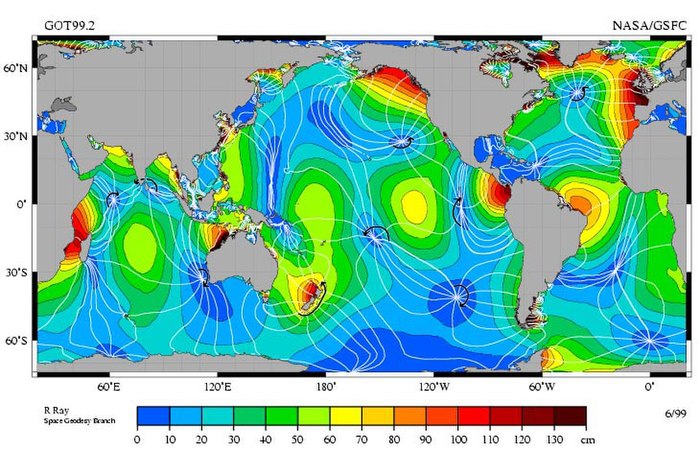
Quote:
|
The M2 tidal constituent, the amplitude indicated by color. The white lines are cotidal lines spaced at phase intervals of 30° (a bit over 1 hr).[4] The amphidromic points are the dark blue areas where the lines come together.
|
It looks like France is situated pretty well for tidal power.